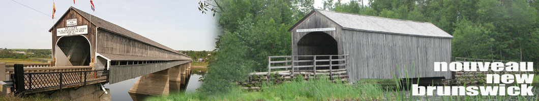
ponts couverts dans le monde
bedeckte Brücken der Welt
世界各地的棚桥
55-02 CARLETON county/comté/grafschaft
7 covered bridges/ponts couverts/bedeckte
holzbrücken
![]()
This symbol indicates this listing has been translated from English to French
and German by ATAWALK
Ce symbole indique que la traduction de cette liste fut effectuer à partir
de l'anglais au Français et à l'Allemand par ATAWALK
Dieses Symbol deutet darauf hin, dass diese Auflistung von ATAWALK vom Englischen
ins Französische und Deutsche übersetzt wurde.
THIS
SECTION OF ATAWALK IS DEDICATED TO THE MEMORY OF
Rosemary Withers
est la dédicasse de cette section d'ATAWALK.net
/Dieser Abschnitt der ATAWALK.net widmet sich der Erinnerung an
COLDSTREAM
| 55-02-05 |
North-east of Coldstream on Ellis Road Au nord-est de Coldstream sur le chemin Ellis Nord-östlich von Coldstream auf Ellis Straße |
North Branch of the Becaguimec River Branche nord de la rivière Bécaguimec Nord Nebenfluß des Becaguimec Flußes |
Ellis or North Becaguimec Bridge #4 Pont couvert Ellis ou de la Bécaguimec no.4 Holzbrücke Ellis oder Bécaguimec No.4 |
3.6 Km east of NB580 on NB104 then 0.4 Km left on Howard Brook Road and right at Ellis Road to the bridge 3.6 Km à l'est de la NB580 sur la NB104 et à gauche sur le chemin Howard Brook et à droite sur le chemin Ellis vers le pont 3,6 km östlich von NB580 auf NB104 dann 0,4 km links in die Howard Bach Straße und rechts auf Ellis Straße zum die Brücke |
1 | 63' 19.2m |
Built in 1909 Construit en 1909 Gebaut in 1909 |
Howe truss Ferme Howe Howe Träger |
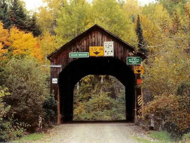
Ellis or Bécaguimec #4, foto Mike MacCarter
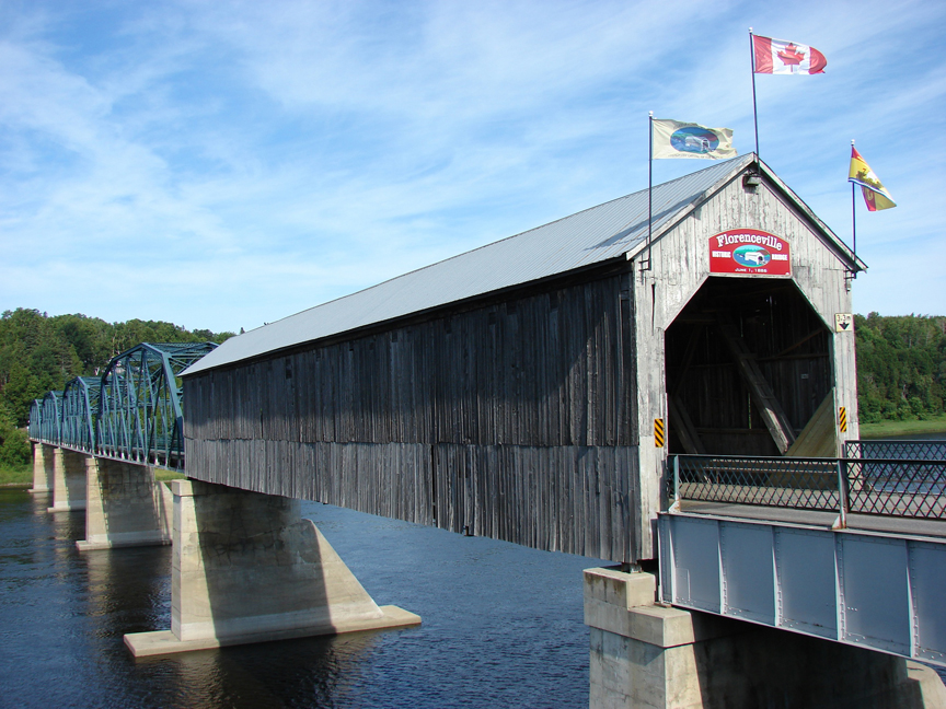
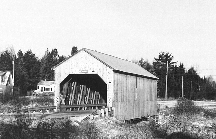
FLORENCEVILLE
| 55-02-06 |
In the town of Florenceville on Old Bridge Road À Florenceville sur le chemin du vieux pont In Florenceville auf alte Brücke Straße |
St. John River Fleuve St-Jean St.Johann Fluß |
Florenceville Bridge Pont de Florenceville Florenceville Brücke |
About 3 Km east of exit 153 on Trans-Canada Hwy 2 on NB110 and right on NB103 Centreville Drive and right again on Bridge Street/Jim Davis Drive to the bridge Environ 3 Km à l'est de la sortie 153 de la route 2, la Trans-Canadienne, sur la NB110 et à droite sur la NB103, le chemin Centreville, et encore à droite la rue du Pont, le chemin Jim Davis vers le pont Ungefähr 3 km östlich der Ausfahrt 153 auf dem Autobahn Trans-Canada 2 auf NB110 und rechts am NB103 Centreville Allee und wieder rechts auf der Brücke Straße/ Jim Davis Allee zum die Brücke |
4 steel spans and 1 covered wooden span on the east side 4 travées en acier, 1 travée en bois couverte 4 Stahl Spannweiten und 1 Holz span auf der Ostseite |
Bridge, pont Brücke Wooden span, |
Built in 1885-86 Construit en 1885-86 Gebaut im Jahren 1885-86 |
Howe truss Ferme Howe Howe Träger |
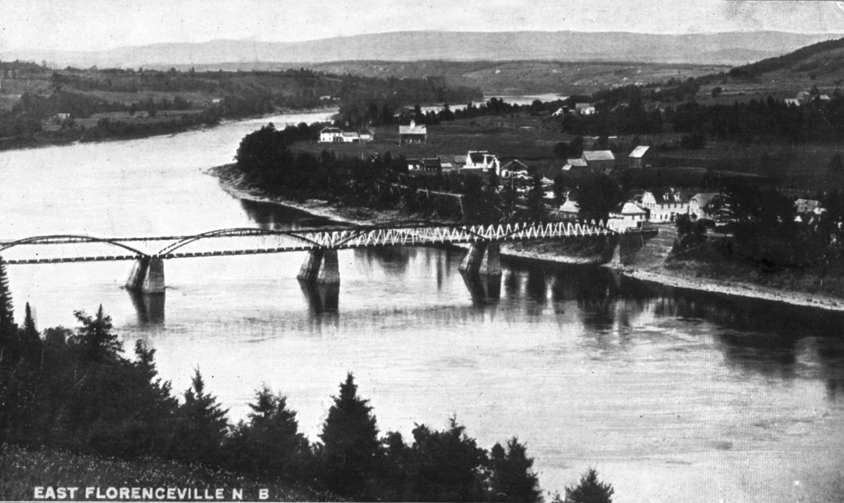
Florenceville at it
first appeared, five uncovered Burr-Arch Trusses 1886-1907
Le pont de
Florenceville, 5 fermes Burr avec arches non-couverte de 1886 à 1907
Die
Florenceville Holzbrücke, 1887-1907, 5 Burr Träger mit Bogen
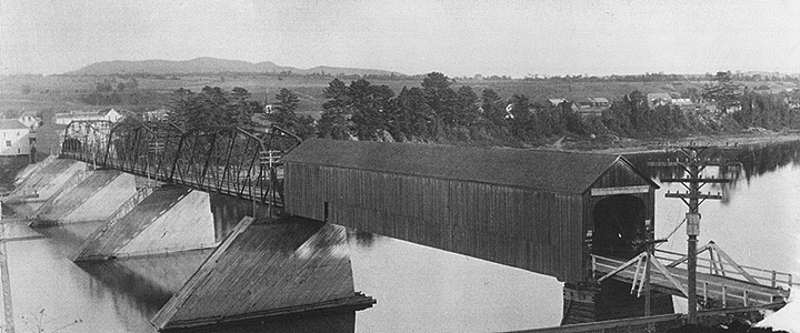
Florenceville between
1907 and 1932, this is as covered as it ever got, 3 central Burr section
replaced by steel but still wooden piers
Le pont de Florenceville
de nos jours, Florenceville now, die Florenceville Brücke mit seinen einzigartigen
hölzernen span wie es jetzt
ist.
Built in 1885-86 as an unhoused Burr-Type wood bridge of 5 spans by Albert Brewster of Carleton, Quebec, in 1907 - the western Burr span is replaced by a Howe truss and covered, 1908 - the eastern Burr span is also replaced by a Howe span and covered as well, 1910 - the 3 middle spans are rebuilt but with steel by the William McNeil Co. of Glasgow, N-S, 1917 - the whole thing is lifted and put on concrete piers and abutments, 1932 - the western Howe truss is destroyed by fire and replaced by another steel truss built by the St. John Dry Dock & Shipbuilding Co.
Construit en 1885-86 par Albert Brewster of Carleton Qc, 5 travées non couvertes Burr avec arches, la travée ouest est remplacer par une travée Howe en 1907, celle du bout-est sera à son tour remplacer en 1908, en 1910, la Cie William McNeil de Glasgow en Nouvelle-Écosse installe 3 travées en acier. En 1917, on sous-lève tout le bataclan pour remplacer les cages de bois par des pilliers de ciment, en 1932 la travée en bois ouest passe au feu, on la remplace par la quatrième travée de fer construite par la Cie des Cales Sêches et Construction Navale de St-Jean.
In 1885/86 als unbehaust 5 Holzspannweiten Burr-Type erbaute von Albert Brewster von Carleton, Quebec, in 1907 - den westlichen Burr span wird durch eine Howe-Träger und bedeckt, 1908 - der östlichen Burr span ersetzt wird ebenfalls ersetzt durch ein Howe Spannweite und mit abgedeckt sind, 1910 eine 3 - Mitte erstreckt werden neu erstellt, sondern mit Stahl von der William McNeil Co. of Glasgow, NS, 1917 - das Ganze wird angehoben und auf konkrete Pfeiler und Widerlager, 1932 - Die westliche Howe setzen Dachstuhl ist durch einen Brand zerstört und durch ein anderes ersetzt Fachwerkträger aus Stahl von der St. John Dry Dock & Shipbuilding Co. gebaut
H A R T L A N D
| 55-02-07 |
In the little town of Hartland east of Trans-Canada Highway 2 Au centre de la petite ville de Hartland, à l'est de la route 2, la Trans-Canadienne In der Zentrum von des Dorf Hartland östlich auf Trans Kanada Autobahn 2 |
St. John River Fleuve St-Jean St.Johann Fluß |
The Hartland Covered Bridge Le grand pont couvert d'Hartland Holzbrücke von Hartland |
About 4.5 Km east of exit 172 on Trans Canada Hwy on NB130, straight on Somerville Road an left on NB103 to Bridge Hill Road down 0.2 Km to bridge Environ 4.5 Km à l'est de la sortie 172 de l'autoroute 2 Trans-Canadienne sur la NB130 et sur la route Somerville jusqu'à la NB103, à gauche jusqu'au chemin Bridge Hill, à droite vers le pont Ungefähr 4,5 km östlich der Ausfahrt 172 auf dem Trans Canada Autobahn auf NB130, weiter auf Somerville Road ein nach links auf NB103, dann rechts auf Hügel der Brücke Straße 0,2 km zum die Brücke |
7 | 1282' 390.7m |
Built in 1899 on wooden cage piers, operated as a toll-bridge until 1906, the structure was lifted and moved to new cement piers and abutments,one western span destroyed by a flash-flood in 1920, fully renovated and covered in 1921, walkway added in 1947 Construit en 1899 sur des cages de bois, opéré comme pont-à-péage jusqu'en 1906, il fut lever et mis sur des pilliers de ciment, un coup d'eau emportait une travée côté ouest en 1920, rénové et finallement couvert en 1921, le trottoir lui fut ajouter en 1947. Im Jahr 1899 auf hölzernen Käfig Pfeiler gebaut, als eine Maut-Brücke betrieben bis 1906, war die Struktur aufgehoben und neue Zement Pfeiler und Widerlager, einer westlichen Spannweite fallen zerstört einem Blitz-Hochwasser im Jahr 1920, komplett renoviert und bedeckt im Jahre 1921, Bürgersteig hat im Jahr 1947 |
Howe truss Ferme Howe Howe Träger |
The longest Covered Bridge in the World today.
Le plus long pont couvert au monde.
Die längste Holzbrücke der Welt heute!
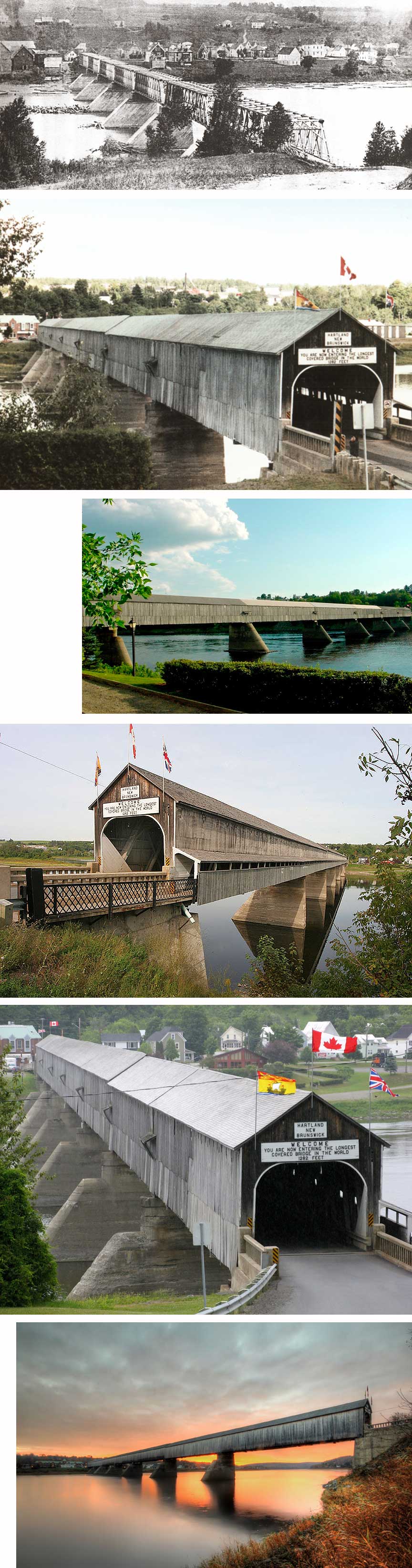
FOTOS by/par/von Les archives du Nouveau/New-Brunswick archives, HARTLAND
1900
Rosemay Withers, Yvon Gervais, Gord Handley, Panoranio, Martin Bergeron FLICKr
SUNSET at Hartland available here from Jason Bennett!
An immensely spectacular bridge, une structure spectaculaire...
eine
spektakuläre
Brücke!
BATH
| 55-02-08 |
North-east of Bath on North Johnville Road Au nord-est de Bath sur le chemin de Johnville-Nord Nord-östlich von Bath auf Hohnville-Nord Straße |
Monquart River Rivière Monquart Monquart Fluß |
Keenan or Monquart River Bridge #3 Pont couvert Keenan ou rivière Monquart no.3 Holzbrücke Keenan oder Monquart Fluß No.3 |
4.8 Km north east of NB105 on NB565 then right 2 miles on Johnville Road and left 3.2 Km on North-Johnville Road to the bridge 4.8 Km au nord de la NB105 sur la NB565 et à droite sur le chemin Johnville, et à gauche sur le chemin Johnville-Nord 3.2 Km vers le pont 4,8 km nordöstlich von NB105 auf NB565 dann rechts 2 Meilen auf Johnville Straße und 3,2 km links über die Nord-Johnville Straße zum die Brücke |
1 | 86' 26.2m |
Built in 1927 Construit en 1927 Gebaut in 1927 |
Howe truss Ferme Howe Howe Träger |
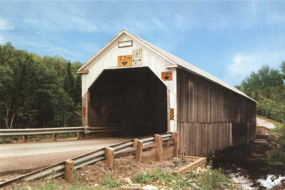
Monquart River
#3 or/ou/oder Keenan, Postcard Rosemary Withers
COLDSTREAM
| 55-02-10 |
South-east of Coldstream on Ashland Road Au sud-est de Coldstream sur le chemin Ashland Südöstlich von Coldstream auf Ashland Straße |
Becaguimec River Rivière Bécaguimec Becaguimec Fluß |
Mangrum, Stormdate or Becaguimec Bridge #3 Pont couvert Mangrum, Stormdale ou Rivière Bécaguimec no.3 Holzbrücke Mangrum, Stormdale oder Becaguimec Fluß No.3 |
6 Km south-east of NB104/570 at Coldstream on Mainstream Road then right 0.6 Km to the bridge 6 Km au sud-est des NB104/570 à Coldstream sur le chemin mainstream et à droite 0.6 Km vers le pont 6 km südöstlich von NB104/570 auf Coldstream on Mainstream Straße, dann 0,6 km rechts auf die Brücke |
1 | 98' 29.8m |
Built in 1909 Costruit en 1909 Gebaut in 1909 |
Howe truss Ferme Howe Howe Träger |
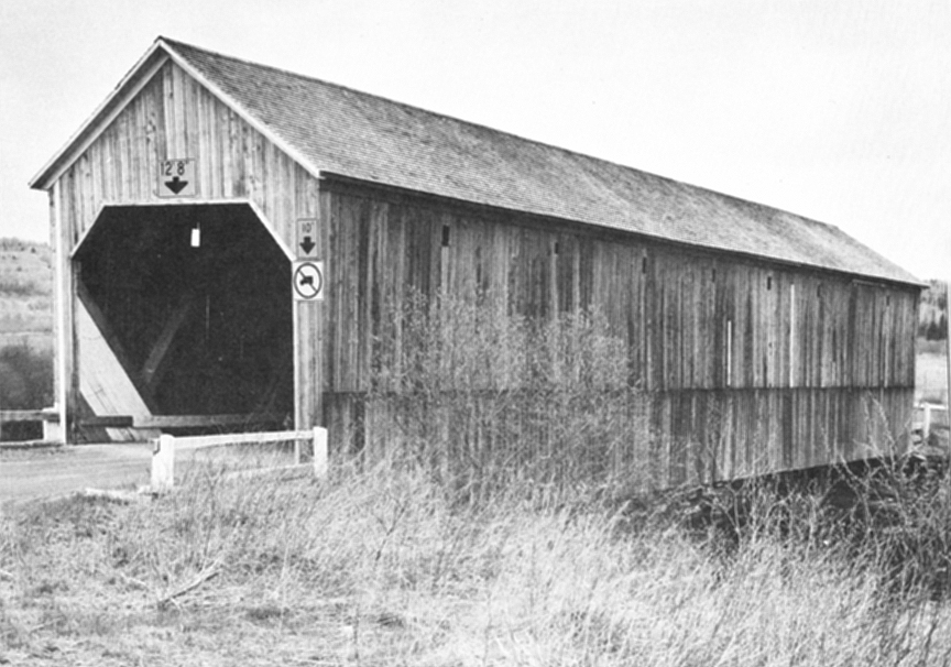
Mangrum, Stormdale or/ou/oder Bécaguimec River #3, foto Rosemary
Withers
BENTON
| 55-02-15 55-15-12 |
At Benton on Benton Road, between Carleton & York Counties À Benton sur le chemin Benton, entre les comtés Carleton et York In Benton auf Benton Straße, zwischen Graftschaften Carleton und York |
Eel River Rivière à l'anguille Aal Fluß |
Benton or Eel River Bridge #3 Pont couvert Benton ou Rivière à l'anguille no.3 Holzbrücke Benton oder Aal Fluß No.3 |
About 11.3 Km north-west of Trans-Canada Highway at exit 212 on NB165 north-west past Meductic and west on and Benton Road, under the Highway and upland to the bridge Environ 11.3 Km au nord-ouest de la sortie 212 de la route 2, la Trans-Canadienne sur la NB165 passer Meductis et à gauche sur le chemin Benton, sous la Trans-Canadienne et dans les terres jusqu'à Benton et le pont Über 11,3 Kilometer nord-westlich von Trans-Canada-Highway an der Ausfahrt 212 auf NB165 Nord-West-Vergangenheit Meductic und Westen auf Benton Straße, unter der Autobahn und der Berggebiete auf die Brücke am Benton |
1 |
107' 32.6m |
Built in 1927 Costruit en 1927 Gebaut in 1927 |
Howe truss Ferme Howe Howe Träger |
Benton or/ou/oder Eel-Anguille-Aal
River #3, foto Rosemary Withers
GRAND SAULT / GRAND FALLS
| 55-02-A |
At the north west edge of Grand Sault/Grand Falls at Inn-by-the-Lake off NB144 À la limite nord-ouest de Grand-Sault/Grand-Falls à l'Auberge-près-du-Lac en bordure de la NB144 An der nordwestlichen Rand des Grand Sault / Grand Falls am Inn-by-the-Lake auf NB144 |
Little Lake Petit lac Kleine See |
Inn-by-the-Lake covered bridge Pont couvert de l'Auberge-près du-Lac Gasthaus am See Holzbrücke |
At the north-western edge of Grand-Falls, off Hwy 2, Trans-Canada Hwy at exit 72 south 1.2 Km on NB108 to NB144, right to the inn on the north side of the road à la llimite nord-ouest de Grand-Sault, 1.2 Km au sud-ouest de la sortie 72 de la route 2, la Trans-Canadienne sur la NB108 et à droite sur la NB144 vers l'Auberge près du Lac du côté nord de la route Am nordwestlichen Rand des Grand-Falls, Hwy 2, Trans-Canada-Highway an der Ausfahrt 72 nach Süden 1,2 km auf NB108 zu NB144, rechts in die Herberge auf der Nordseite der Straße |
1 | 15' 4.5m |
Built in the sixties Construit dans les années soixante Erbaut in den sechziger Jahren |
Stringer Putres continues Träbalken |
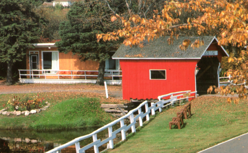
Le plus petit pont couvert au monde???, près de Grand-Sault, Auberge-près-du-Lac,
une carte postale.
The smallest covered bridge in the world near Grand Sault/Grand Falls,
photo
from
the Inn-by -the-Lake postcard.
Die kleinste bedeckte Brücke der Welt in der Nähe von Grand
Sault / Grand Falls, Foto aus dem Inn-by-the-Lake Postkarte.