ponts couverts dans le monde
bedeckte Brücken der Welt
世界各地的棚桥
29-03 Cheshire county/comté/grafschaft
6 covered bridges/ponts couverts/bedeckte holzbrücken
![]()
This symbol indicates this listing has been translated from English to French
and German by ATAWALK
Ce symbole indique que la traduction de cette liste fut effectuer à partir
de l'anglais au Français et à l'Allemand par ATAWALK
Dieses Symbol deutet darauf hin, dass diese Auflistung von ATAWALK vom Englischen
ins Französische und Deutsche übersetzt wurde.
ASHUELOT
|
29-03-02 |
In the town of Winchester at Ashuelot Dans la ville de Winchester au village d'Ashuelot In der Stadt von Winchester am Dorf von Ashuelot |
Ashuelot river Rivière Ashuelot Ashuelot |
Upper Village Bridge Pont couvert du haut village Obere Dorf- Holzbrücke |
1.7 miles west of NH10 at Winchester on NH 119 and then left on old Ashuelot Road to the bridge 1.7 miles à l'ouest de la NH10 à Winchester sur la NH119 et à gauche sur le vieux chemin d'Ashuelot vers le pont 1.7 Meilen westlich von NH10 bei Winchester auf NH 119, dann linke
auf alter Ashuelot Straße zur Brücke |
2 |
160' 48.7m |
Built in 1864 possibly by Nicholas Powers Construit en 1864 possiblement par Nicholas Powers Vielleicht errichtet 1864 durch Nicholas Powers |
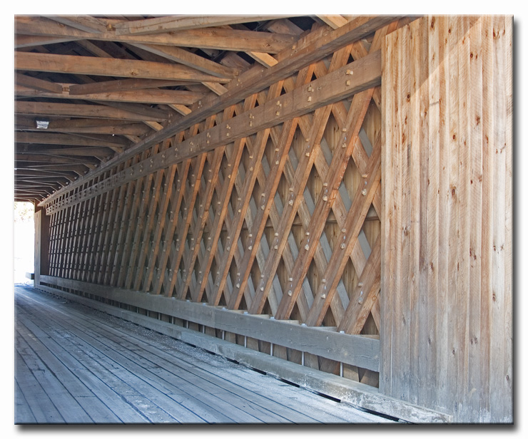
Town lattice Treillis Town Town Träger |
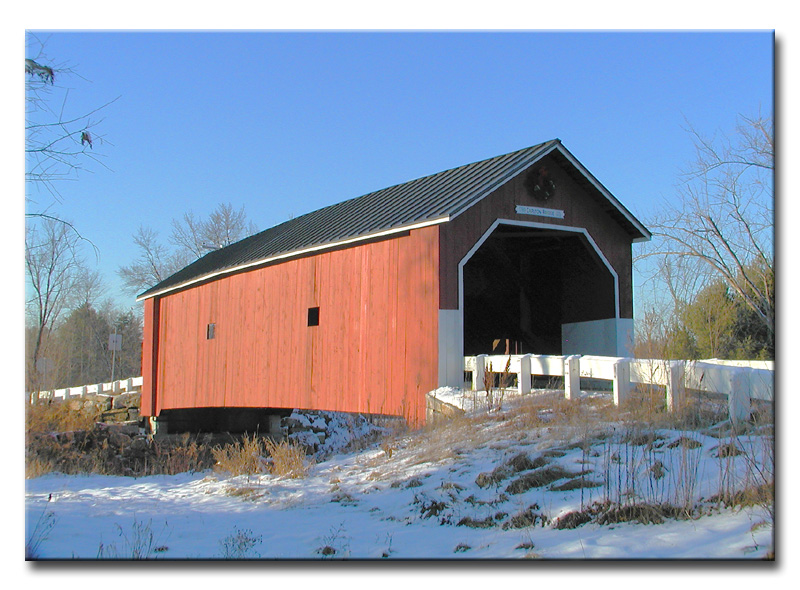
The amazing photography of eJohn Waldron, the Upper Village covered bridge
at Ashuelot, NH.
http://www.pbase.com/ejohnw
WINCHESTER
|
29-03-03 |
West of NH10 north of Winchester À l'ouest de la NH10 au nord de Winchester Westlich von NH10, Norden von Winchester |
Ashuelot river Rivière Ashuelot Ashuelot |
Coombs Bridge Pont couvert Coombs Coombs Holzbrücke |
About 4.5 miles north of Winchester on NH10 then left half a mile to the bridge on Old Westport Road Environ 4.5 miles au nord de Winchester sur la NH10 et à gauche un demi mile sur le vieux chemin Westport vers le pont Ungefähr 4.5 Meilen Norden von Winchester auf NH10 dann linke
0.5 Meile zur die Brücke auf alte Westport Straße |
1 |
118' 35.9m |
Built in 1837 by Anthony Coombs Construit en 1837 par Antoine Coombs Gebaut in 1830 durch Anthony Coombs |
Town lattice Treillis Town Town Träger |
The photography of eJohn Waldron, the Coombs covered bridge.
WEST-SWANZEY
|
29-03-04 |
In the town of West Swanzey on Main Street Sur la rue Principale à West-Swanzey In der Stadt von West-Swanzey auf Hauptstraße |
Ashuelot river Rivière Ashuelot Ashuelot |
Thompson or West Swanzey Bridge Pont couvert Thompson ou de West Swanzey Thompson oder West Swanzey Holzbrücke |
Environ 4 miles au sud-west de Keene sur la NH10 jusqu'à West-Swanzey et à gauche 0.3 miles sur la rue Main, Principale Ungefähr 4 Meilen Süd westlich von Keene auf NH 10 dann
linke 0.3 Meile zur die Brücke auf Hauptstraße in West-Swanzey |
2 |
159' 48.4m |
Built in 1832 by Zadoc Taft Construit en 1832 par Zadoc Taft Gebaut in 1832 durch Zadoc Taft |
Town lattice Treillis Town Town Träger |
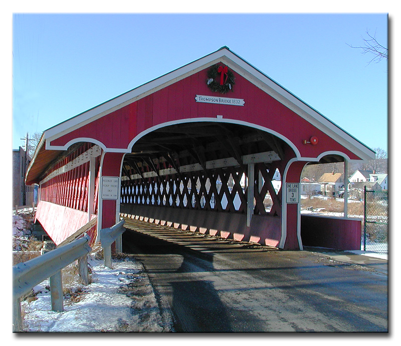
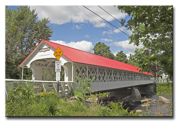
The photography of eJohn Waldron, the classic village bridge, West-Swanzey, NH
SAWYERS-CROSSING
|
29-03-05 |
South of Keene on Sawyers Crossing Road Au sud de Keene sur le chemin de Sawyers-Crossing Süden von Keene auf Sawyers überfahrt-Straße |
Ashuelot river Rivière Ashuelot Ashuelot |
Cresson or Sawyers Crossing Bridge Pont couvert Cresson ou de Sawyers Crossing Cresson oder Sawyers Crossing Holzbrücke |
About 3 miles south of Keene on NH10 then left 2 miles to the bridge on Sawyers Crossing road Environ 3 miles au sud de Keene sur la NH10 et à gauche 2 miles sur le chemin Sawyers Crossing Ungefähr 3 Meilen Süden von Keene auf NH10 dann linke
2 Meilen zur die Brücke auf Sawyers Crossing Straße |
2 |
159' 48.4m |
Built in 1859, restored in 1996 Construit en 1859, restaurer en 1996 Gebaut in 1859, wieder hergestellt 1996 |
Town lattice Treillis Town Town Träger |
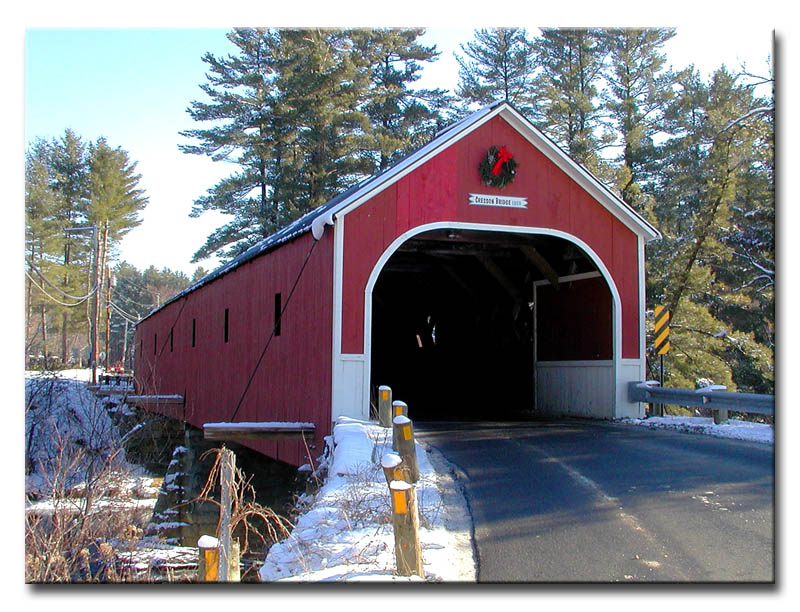
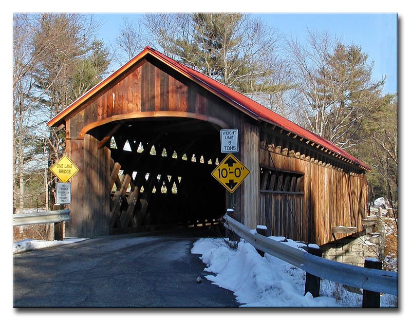
The photography of eJohn Waldron, the Sawyers Crossing or Cresson covered bridge
WEST-SWANZEY
|
29-03-06 |
South of West-Swanzey on old NH10 Au sud de West-Swanzet sur la vieille route NH10 Süden des West-Swanzey auf altem NH10 |
Ashuelot river Rivière Ashuelot Ashuelot |
Slate Bridge Pont couvert Slate Slate Holzbrücke |
About 6 miles south of Keene past West-Swanzey on NH10 then left on the old Hwy 0.4 mile to the bridge Environ 6 miles au sud de Keene sur la NH10 passer West-Swanzey et à gauche sur la veille route 0.4 mile Ungefähr 6 Meilen Süden von Keene hinter Westen-Swanzey dann linke auf das alte NH10, 0.4 Meile zur die Brücke |
1 |
145' 44.1m |
Built in 1800 for the Slate family, rebuilt in 1842, 1862 and 1993 Construit en 1800 pour la famille Slate, reconstruit en 1842, 1862 et 1993 Errichtet 1800 für die Slate Familie, umgebaut 1842, 1862 und 1993 |
Town lattice Treillis Town Town |
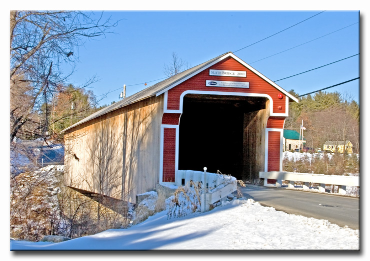
The photography of eJohn Waldron, the new Slate covered bridge
EAST-SWANZEY
|
29-03-07 |
West of East Swanzey on Carleton Road À l'ouest de Swanzey-Est sur le chemin Carlton Westlich von Ost-Swanzey auf Carleton Straße |
South Branch of the Ashuelot river branche sud de la rivière Ashuelot Süden Ashuelot |
Carlton Bridge Pont couvert Carlton Carlton Holzbrücke |
About 4.5 miles south of Keene on NH 32 then left on Carlton Road 0.3 mile to the bridge Environ 4.5 miles au sud de Keene sur la NH32 et à gauche 0.3 miles sur le chemin Carlton Ungefähr 4.5 Meilen Süden von Keene auf NH 32 dann linke
auf Carlton Straße 0.3 Meile zur die Brücke |
1 |
69' 21m |
Built in1789, rebuilt in 1869, restored in 1996 Construit en 1789, reconstruit en 1869 et restaurer en 1996 Errichtet 1789, umgebaut 1869, wieder hergestellt 1996 |
Queen post truss Ferme Queen Queen Träger |
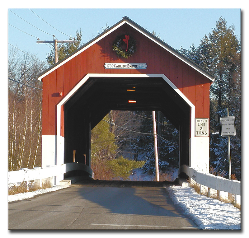
The photography of eJohn Waldron, the Carlton bridge near East-Swanzey, NH.