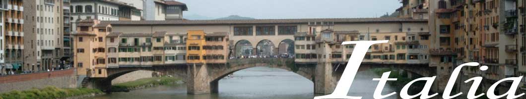
ponts couverts dans le monde
bedeckte Brücken der Welt
世界各地的棚桥
IT-11 Lombardia / Lombardy
Lombardie /Lombardei /
伦巴第
3 bedeckte Holzbrücken / ponts
couverts / covered bridges /三廊桥
Dieses Symbol deutet darauf hin, dass diese Auflistung von ATAWALK vom Englischen
ins Französisch, Deutsche und Chinesisch übersetzt wurde.
Ce symbole indique que la traduction de cette liste fut effectuer à partir
de l'Anglais au Français, à l'Allemand et au Chinois par ATAWALK
This symbol indicates this listing has been translated from English to French, German and Chinese by ATAWALK
此符号表示此物品已被翻译从英语到法语,德语和ATAWALK中
PAVIA PROVINCE/PROVINZ 帕维亚省
PAVIA
| IT-11-01 |
In the centre of Pavia Au centre de la ville de Pavia In der Zentrum von des Stadt Pavia |
Ticino River Rivière Ticino Ticino Fluß |
Covered Bridge - ponte coperto le pont couvert Bedeckte Brücke |
About 75 Km south of Milan on E62/A7 to Bereguardo-Pavia exit and east on A53 via Reccordo Bereguardo Pavia to A54 south in Rottone and east on Strada Canarazzo to Via Luigi Barette to Via 25 Aprile to the bridge. Environ 75 Km au sud de Milan sur la E62/A7 jusqu'à la sortie Bereguardo-Pavia et vers l'est sur la A53 via Reccordo Bereguardo Pavia jusqu'à la A54 au sud dans Rottone et vers l'est sur Strada Canarazzo vers Via Luigi Barette et Via 25 Aprilejusqu'au pont. Über 75 Km südlich von Mailand am E62/A7 zu Bereguardo-Pavia zu verlassen und nach Osten auf A53 via Reccordo Bereguardo Pavia zur A54 nach Süden in Rottöne und Osten auf Strada Canarazzo zu Via Luigi Barette der Via 25 Aprile, um die Brücke. |
5 | 710' 216m |
Originally built in 1354, rebuilt after WWII in 1951 Construit en 1354, reconstruit après la guerre en 1951 Gebaut in 1354, Weideraufbau im Jahr 1951 |
Masonry arches Arches en béton Betonbogen |
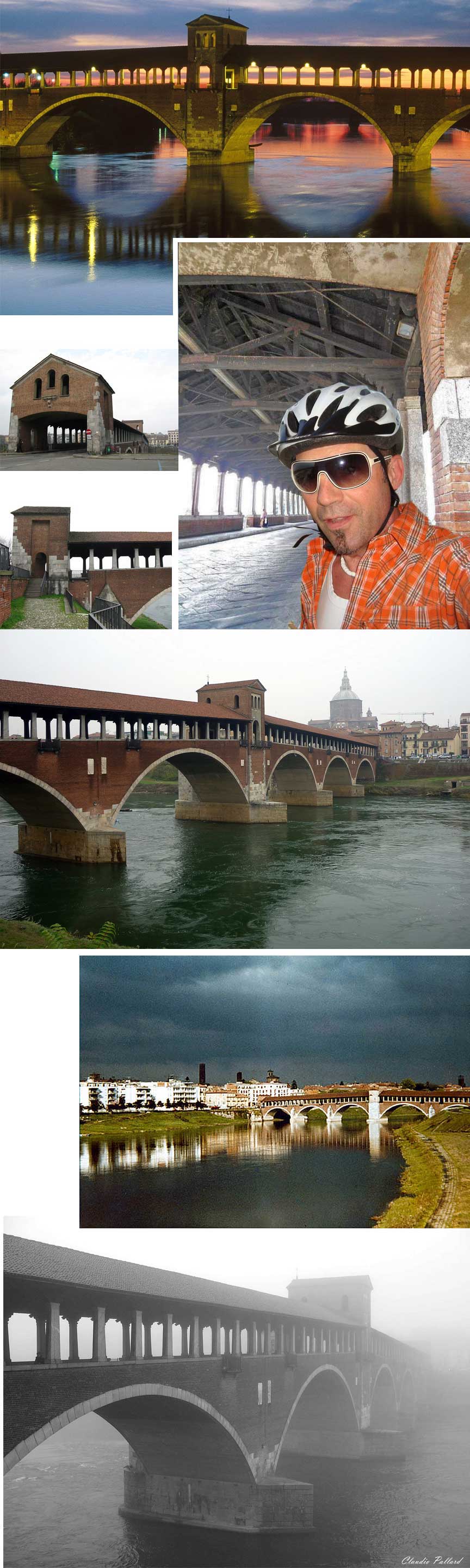
Fotos Herrad Elizabeth Taubenheim Structurae, WIKIPEDIA, Gianna Mazzolin Dassios, Claudio Pallard
SONDRIO PROVINCE/PROVINZ 松德里奥省
SANTA CATERINA VALFURVA
| IT-11-02 |
In the centre of the village of Santa Caterina Valfurva Au centre du village de Sainte-Caterine de Valfurvie In der Zentrum von des Dorf Sankta Katerina Valfurva |
Frodolfo creek Ruisseau Frodolfo Frodolfo Bach |
Frodolfo bridge Pont couvert du Frodolfo Frodolfo Holzbrücke |
About 160 Km north of Verona on E45/A22 past Trento, then north west on SP235 and on SS43 through Mezzocorona and Cless to SS42 west to Ponte di Legno then north on SS300 to Santa Caterina in the in Stelvio National Park. Environ 160 Km au nord de Vérone sur la E45/A22 passer Trente, et vers le nors ouest sur la SP235 et sur la SS43 par Mezzocorona et Cless jusqu'à la SS42 ouest vers Ponte di Legno et au nors sur la SS300 jusqu'à Sainte Caterine dans le parc national Stelvio Über 160 km nördlich von Verona am letzten E45/A22 Trient und dann nordwestlich auf SP235 auf SP 43 einschlagen und durch Mezzocorona und Cless auf SS42 Westen nach Ponte di Legno dann nach Norden auf SS300 nach Santa Caterina in der im Nationalpark Stelvio. |
1 | 25' 7m |
No building date known Date de construction inconnue Unbekanntes Konstruktiondatum |
Stringer Poutres continues Tragbalken |
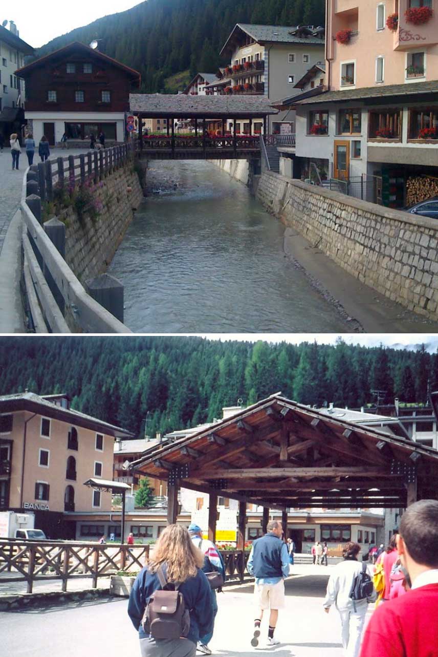
Fotos Stefano Incerpi & Angelo Leone, GoogleMap
TRENTINO PROVINCE/PROVINZ 特兰托省
PANCHIA
| IT-11-03 |
Just south of town at Panchia Juste au sud de Panchia Südlich von des Dorf Panchia |
Avisio river Rivière Avisio Fluß Avisio |
Panchia covered bridge Pont couvert de Panchia Holzbrücke von Panchia |
About 130 Km north of Verona on E45/A22 past Trento to Lavis then east on SS612 to SS232 at Castello Molina di Fiemme east to Panchia south of town north of SS232 off Via Cavelonte Environ 130 Km au nord de Vérone sur la E45/A22 passer Trente sur Lavis et vers l'est sur la SS612 jusqu'à la SS232 à Castello Molina di Fiemme et vers l'est jusqu'à Panchia au sud du village et au nord de la SS232 par la Via Cavelonte Über 130 km nördlich von Verona am letzten E45/A22 Trento zu Lavis dann östlich auf SS612 SS232 bis im Castello Molina di Fiemme Osten nach Panchia südlich der Stadt nördlich von SS232 der Via Cavelonte |
1 | 88' 27m |
...rebuilt in 1948 reconstruit en 1948 Wiederaufbau im Jahr 1948 |
Arch & stuts Arches en contrefiche Bogen mit Streben |
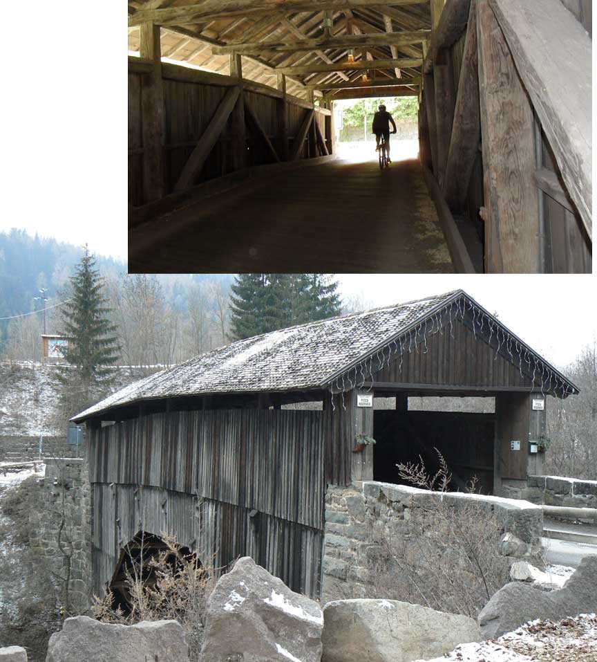
Fotos Reni & Krisz, Roberto Marangoni
IT-17 Trentino-Alto Edige / Südtirol
6 bedeckte Holzbrücken / ponts
couverts / covered bridges /六廊桥
Dieses Symbol deutet darauf hin, dass diese Auflistung von ATAWALK vom Englischen
ins Französisch, Deutsche und Chinesisch übersetzt wurde.
Ce symbole indique que la traduction de cette liste fut effectuer à partir
de l'Anglais au Français, à l'Allemand et au Chinois par ATAWALK
This symbol indicates this listing has been translated from English to French, German and Chinese by ATAWALK
此符号表示此物品已被翻译从英语到法语,德语和ATAWALK中
BOLZANO/BOXEN PROVINCE/PROVINZ 博尔扎诺省
| I-17-01 |
At Fie north east of Bolzano | Isarco (Eisack) River | Passo di Fie, Volsewrsteig foot Bridge | North east of Bolzano about 15 Km on A22/E45 then right on cut off to Fie | 3 | 206' | No building date known | Queen truss |
| I-17-02 |
At Campodazzo (Atzwang) | Isarco (Eisack) River | Campodazzo or Atzwang Bridge | North east of Bolzano about 18 Km on A22/E45 to the village of Campodazzo | 2 | 180' | Built in 1818 | King & Queen truss |
| I-17-03 |
At the Stazione Castelrotto,
In der Nahe von der Bahnof in des Dorf Kastelruth |
Isarco (Eisack) River | Ponte della Stazione Castelrotto Bridge | North east of Bolzano about 21 Km on Ponte della Stazione Castelrotto to the railroad station | 1 | 99' | Built in the 1800s | King, Queen truss and struts |
| I-17-04 |
North of Fortezza (Franzenfeste) at Oberau | Isarco (Eisack) River | Oberau Bridge | North east of Bolzano about 35 Km to Bressanone (Brixen) on A22/E45 north to Fortezza continue north to Oberau on west side of i12. | 2 | 108' | Built in 1942 | Overlapped Multiple-Queen truss |
| I-17-05 |
At Bressanone-Novacelle (Brixen-Neustift) | Isarco (Eisack) River | Ponte Isarco Bridge | 3 Km north east of Bressanone east on A22/E45 to Novacello (Neustift) | 2 | 79' | Built in 1987 | Queen truss & struts |
MERANO-LAGUNDO
| I-17-06 |
At the western edge of Merano Lagundo À la limite ouest de Merano Lagundo Am der Westlich rand der Stadt Meran-Algund |
Adige River Rivière Adige Etsch Fluß |
Adige river bridge Pont couvert de l'Adige Etsch Holzbrücke |
About 30 Km north west of Bolzano (Bozen) on SS38 to Merano About 30 Km north west of Bolzano (Bozen) on SS38 to Merano About 30 Km north west of Bolzano (Bozen) on SS38 to Merano |
2 | 210' | Built in 1970 Construit en 1970 Gebaut in 1970 |
Howe truss (Western) Ferme Howe version de l'ouest Howe Träger (Westen versionen) |
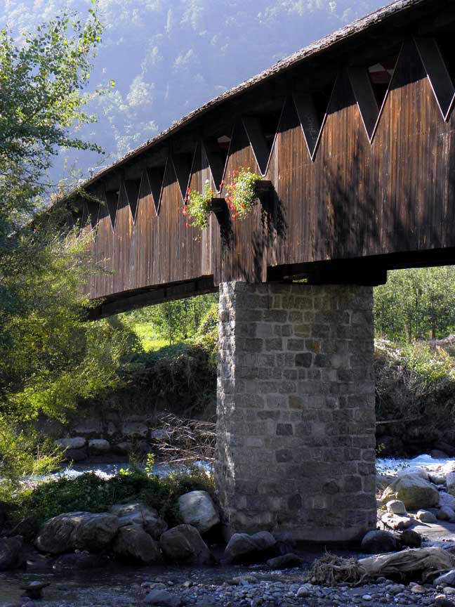
Foto Stedinger85 PANORAMIO
MONTE DI MEZZO
| I-17-08 |
At Monte di Mezzo north of Renon | Renon (Ritten) River | NA | 1 | 82' 25m |
No building date | Queen & struts |
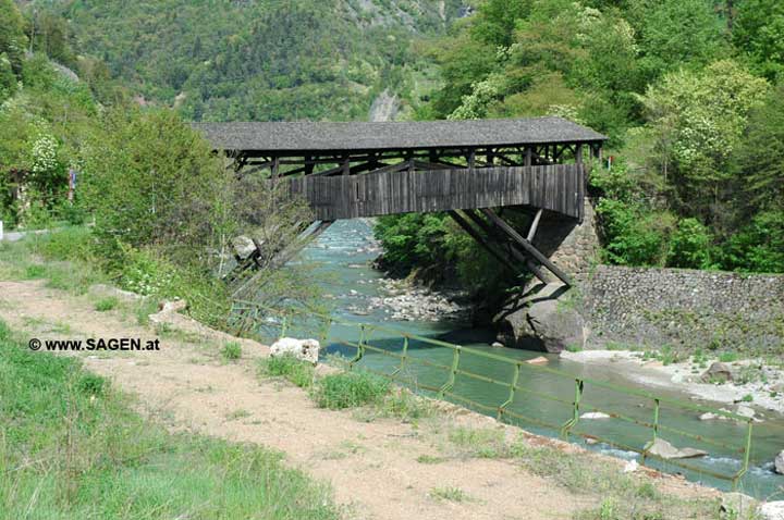
Foto www.SAGEN.at
IT-18 Toscana/Tuscany/Toscane
1 bedeckte Holzbrücke / pont
couvert / covered bridge /一廊桥
Dieses Symbol deutet darauf hin, dass diese Auflistung von ATAWALK vom Englischen
ins Französisch, Deutsche und Chinesisch übersetzt wurde.
Ce symbole indique que la traduction de cette liste fut effectuer à partir
de l'Anglais au Français, à l'Allemand et au Chinois par ATAWALK
This symbol indicates this listing has been translated from English to French, German and Chinese by ATAWALK
此符号表示此物品已被翻译从英语到法语,德语和ATAWALK中
FIRENZE/FLORENCE PROVINCE/PROVINZ 佛罗伦萨省
FIRENZE
| I-18-01 |
In downtown Florence Au cetre ville de Florence In der Florenz Stadt Zentrum |
Arno River Rivière Arno Fluß Arno |
The Old bridge, Ponte Vecchio Le Ponte Vecchio Das Ponte Vecchio |
Downtown Florence, at the end of the Via Romana, accessible through Via Maggio and left on Strada Borgo to the Bridge Au centre de Florence à la fin de la Via Roman, accessoible par la Via Maggio et à gauche sur Strada Borgo vers le pont. Stadtzentrum von Florenz, am Ende der Via Romana, zugänglich über Via Maggio und links auf die Strada Borgo auf der Brücke |
3 | 300' 90m |
Built in 1345 by Taddeo Gaddi, fully restored after the devastating 1967 floods. First wood bridge on the site dates from 996, second was a stone arch built in 1117, destroyed again in 1333 but which fondations were used for the present bridge Premier pont de bois date de 996, second pont fut en pierre et date de 1117, detruit en 1333, les fondations furent utiliser pour le pour le pont actuel qui date de 1345 et qui fut construit par Taddéo Gaddi, restaurer après sa quasi-complète destruction en 1967. Erbaut im Jahre 1345 von Taddeo Gaddi, voll nach dem verheerenden Hochwasser 1967 restauriert. Erste Brücke aus Holz auf dem Gelände stammt aus dem Jahr 996, war ein zweiter Steinbogen in 1117 gebaut, im Jahr 1333 wieder zerstört, aber die Fondations werden für die derzeitige Brücke eingesetzt |
Closed-spandrel segmental stone arch bridge with dwelling and commerces on-deck, plus elevated passage reserved for the clergy. Arche de pierre allège segmentaire avec habitation et des commerces, avec passage surélevé réservé au clergé. Geschlossene Brüstung segmentale Steinbogenbrücke mit Wohn-und commerces On-Deck, plus erhöhter Durchgang für den Klerus vorbehalten. |
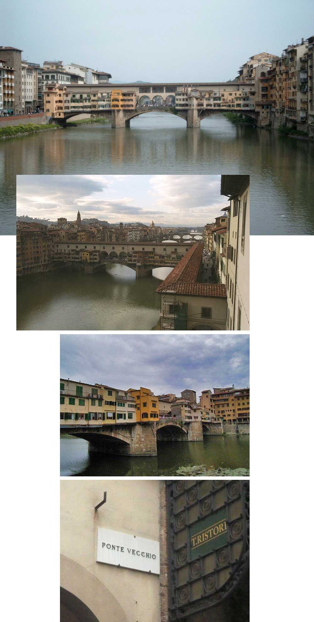
Fotos WIKIPEDIA, philg@mit.edu, and from Elvin Loh
IT-19 Umbria/Ombrie
1 bedeckte Holzbrücke / pont
couvert / covered bridge /一廊桥
Dieses Symbol deutet darauf hin, dass diese Auflistung von ATAWALK vom Englischen
ins Französisch, Deutsche und Chinesisch übersetzt wurde.
Ce symbole indique que la traduction de cette liste fut effectuer à partir
de l'Anglais au Français, à l'Allemand et au Chinois par ATAWALK
This symbol indicates this listing has been translated from English to French, German and Chinese by ATAWALK
此符号表示此物品已被翻译从英语到法语,德语和ATAWALK中
PURUGIA/PÉROUSE PROVINCE/PROVINZ 佩鲁贾省
PERUGIA
| I-19-01 |
In the south east corner of Perugia Dans la partie sud-est de Pérouse In der süd-seite des Stadt Perugia |
Teber Rivière Tibre Tevere Fluß |
St. John Bridge Pont St-Jean, ponte San-Giovanni Sankt-Johannes Brücke |
160 Km north of Rome and south-east of downtown Perugia at Ferreira just north east of E45 at Ponte San Giovanni exit north on Via Alessandro Manzoni and right on Via Ponte Vecchio to the bridge 160 Km au nord de Rome et au sud-est de Pérouse à Ferreira juste au nord est de la E45 à la sortie Ponte San Giovanni et vers le nord sur la Via Alessandro Manzoni et à droitew sur la Via Ponte Vecchio vers le pont couvert 160 km nördlich von Rom und südlich-östlich der Innenstadt von Perugia an Ferreira nur nordöstlich von E45 in Ponte San Giovanni Ausfahrt nach Norden auf der Via Alessandro Manzoni und rechts in die Via Ponte Vecchio an der Brücke |
3 | 350' 106 m |
Built in 1999, replacing a Bailey bridge built after WWII Construit en 1999, remplace un pont Bailey construit après la guerre Im Jahr 1999 erbaut und ersetzte eine Bailey-Brücke nach dem Zweiten Weltkrieg gebaut |
Laminated beams Poutres laminées Brettschichtholz |
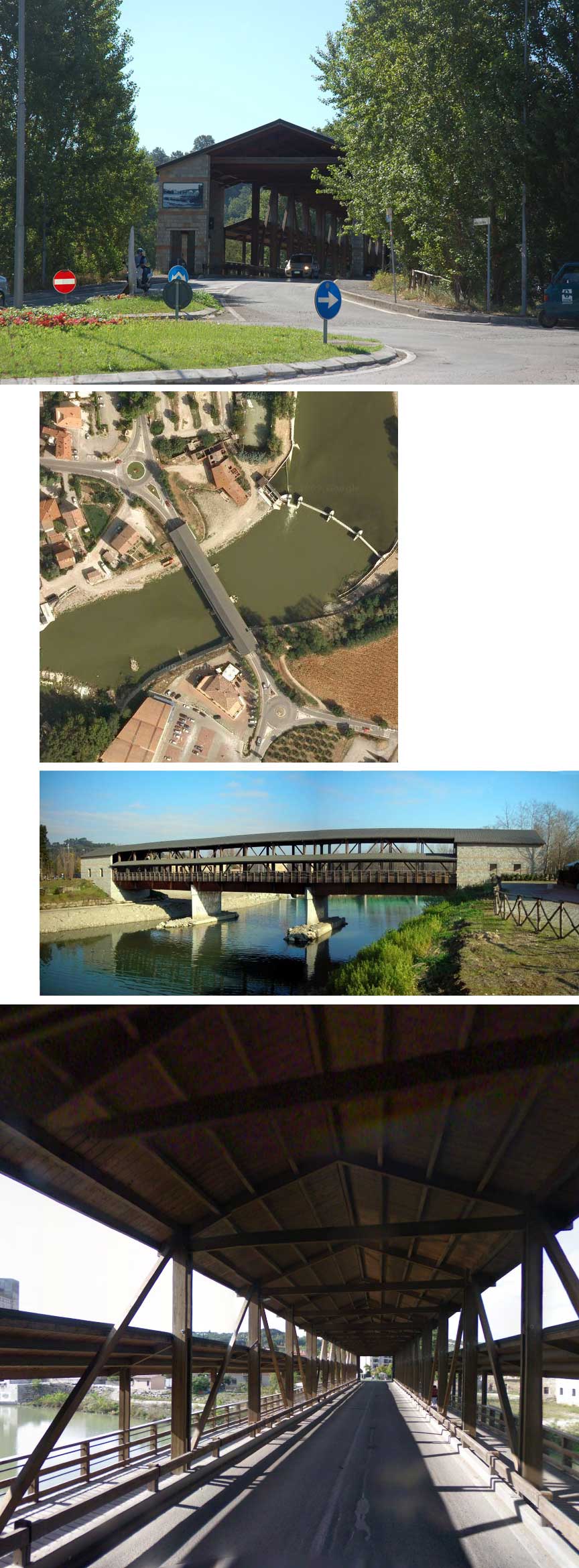
Fotos WIKIPEDIA & Gianna Mazzolin Dassios
IT-20 Veneto/Vénétie/Venetien
3 bedeckte Holzbrücke / pont
couvert / covered bridge /三廊桥
Dieses Symbol deutet darauf hin, dass diese Auflistung von ATAWALK vom Englischen
ins Französisch, Deutsche und Chinesisch übersetzt wurde.
Ce symbole indique que la traduction de cette liste fut effectuer à partir
de l'Anglais au Français, à l'Allemand et au Chinois par ATAWALK
This symbol indicates this listing has been translated from English to French, German and Chinese by ATAWALK
此符号表示此物品已被翻译从英语到法语,德语和ATAWALK中
VENICE/VENISE/VENEDIG PROVINCE/PROVINZ 威尼斯省
VENEZIA
| I-20-01 |
Behind the Doge Palace downtown Venice connecting to the old prison À l'arrière du palais des Doges, pour aller à l'acienne prison Hinter dem Dogenpalast in Venedig Innenstadt Anschluss an das alte Gefängnis |
Palace Canal du Palais Schloß Kanal |
Bridge of Sighs Pont des soupirs Seufzerbrücke |
At Plaza San Marco in the centre of Venice behind the Doge palace, between the palace and the old prison Au cantre de Venise, à la place St-Marc, derrière le palais des Doges, entre ce dernier et l'ancienne prison Auf der Plaza San Marco im Zentrum von Venedig hinter dem Dogenpalast, zwischen dem Schloss und dem alten Gefängnis |
1 | 36' 11m |
Designed by Antoni Contino (whose uncle Antonio da Ponte had designed the Rialto Bridge), and built in 1602. Dessiner par Antoni Contino (dont l'oncle, Antonio da Ponte dessinat le pont du Rialto) achevé en 1602. Entworfen von Antoni Contino (dessen Onkel Antonio da Ponte hatte die Rialto-Brücke entworfen), und baute im Jahre 1602. |
Limestone arch Arche en pierre de carrière Kalkbogen |
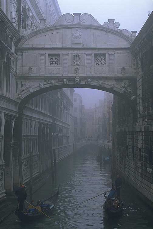
Foto philg@mit.edu
| I-20-02 |
Over the Grand Canal at mid-town Venice Sur le Grand Canal au centre de Venise Über dem Große Kanal am der Mitte der Stadt Venedig |
Grand Canal Große Kanal |
Rialto bridge Pont du Rialto Rialto Brücke |
In mid-town Venice about 1/2 Km north of Plaza San Marco, accessible by land or water, off Pius X Alley Au centre de Venise about 1/2 Km au nord de la place St-Marc, accessible par mer ou par terre, juste au bout de l'allée Pie X In der Mitte der Stadt Venedig ca. 1/2 km nördlich der Plaza San Marco, erreichbar über Land oder Wasser, aus Pius X. Gasse |
1 | 94.5' 28.8 m |
Designed by Antonio da Ponte, completed in 1591. Dessiné par Antonio da Ponte, achevé en 1591. Entworfen von Antonio da Ponte, im Jahre 1591 abgeschlossen. |
Marble arch Arche en marbre Marmorbogen |
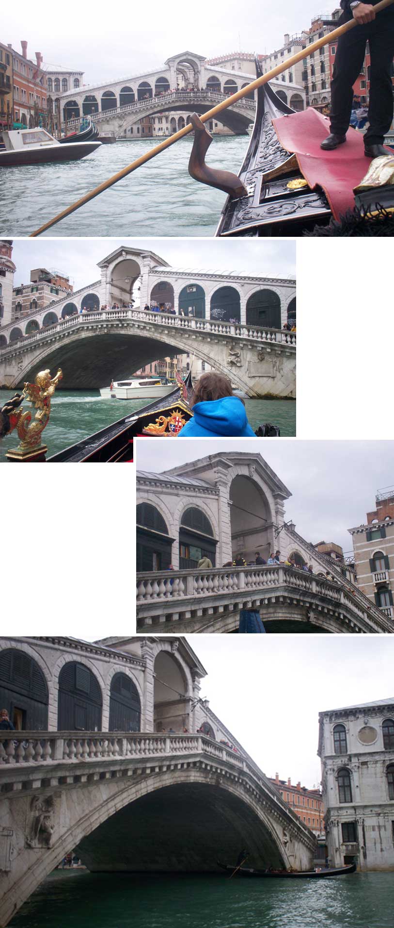
Fotos Frank Perry
VICENZA PROVINCE/PROVINZ 维琴察省
BASSANO DEL GRAPPA
| I-20-03 |
In town at Bassano Del Grappa Au centre de Bassano Del Grappa In der Stadt Zentrum von Bassano Del Grappa |
Brenta Rivière Brenta Brenta Fluß |
Bridge of the Alpini Pont des Alpini Alpini Holzbrücke |
About 80 Km north west of Venice on A4/A57 to Vigonza and E70 to Vigodarzere and north on SS/SP47/67 combo to Bassano Del Grappa, to the centre of town and best access from the west off Viale Diaz to Via Vincenza to Via Angarano to the bridge Environ 80 Km au nord ouest de Venise sur la A4/A57 vers Vigonza and E70 to Vigodarzere and north on SS/SP47/67 combo to Bassano Del Grappa, to the centre of town and best access from the west off Viale Diaz to Via Vincenza to Via Angarano to the bridg Etwa 80 km nordwestlich von Venedig auf A4/A57 bis Vigonzaand E70 zu Vigodarzere und Norden auf SS/SP47/67 Combo zu Bassano Del Grappa, auf der Mitte der Stadt und am besten den Zugang von Westen aus Viale Diaz auf die Via Vincenza zu Via Angarano zu die Brücke |
5 | 210' 64 m |
Designed in 1569 by the architect Andrea Palladio to replace a pre-existing construction from 1209. Destroyed in 1748, rebuilt in 1751. tavern on bridge since 1779. Dessiné en 1569 par l'architecte Andrea Palladio pour remplacer une structure datant de 1209. Détruit en 1748, reconstruit en 1751. Une taverne s'y trouve depuis 1779. Entwickelt im Jahre 1569 von dem Architekten Andrea Palladio, eine bereits bestehende Bau aus dem Jahr 1209 ersetzen. Zerstört in 1748, im Jahre 1751 wieder aufgebaut. Taverne auf der Brücke seit 1779. |
Beam and struts Poutres en contrefiches Balken mit Streben |
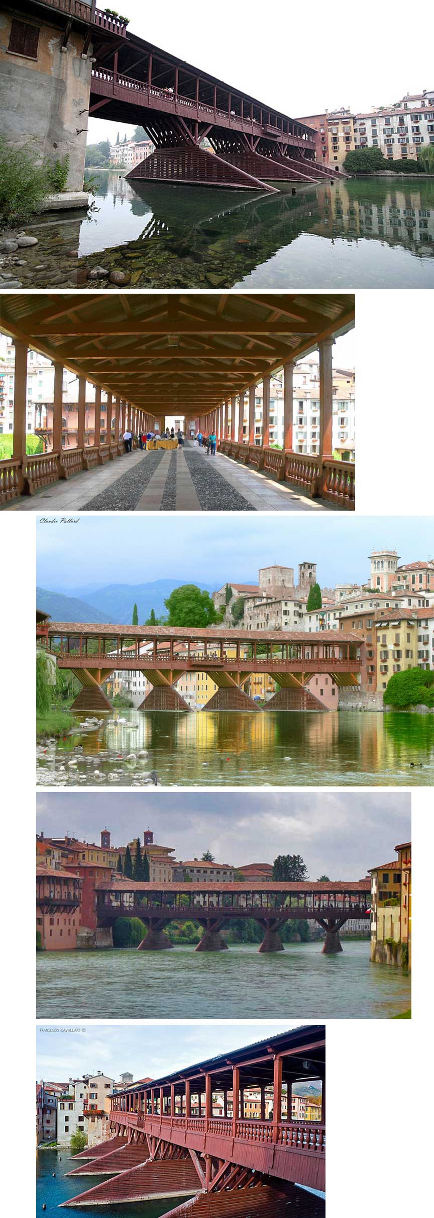
Foto WIKIPEDIA, Claudio Pallard, Francesco Cavallani