- Home
Acceuil
Startseite
主页 - To The Bridges
Vers les ponts
Zum die Brücken
通往棚桥- America Amerique
美洲 Amerika- USA-United States of America
États-Unis d'Amérique
Vereinigte Staaten von Amerika East/Est/Ost美利坚合众国 - Carolinas North 33 & South 40
Caroline du nord et du sud - Connecticut 07
- Delaware 08
- Georgia Georgie 10
- Maine 19
- Maryland 20
- Massachusetts 21
- New-Hampshire 29
- New-Jersey 30
- New-York 32
- Albany 32-01
- Broome 32-04
- Cattaragus 32-05
- Cayuga 32-06
- Delaware 32-13
- Erie 32-15
- Essex 32-16
- Fulton 32-18
- Genesee 32-19
- Herkimer 32-22
- Jefferson 32-23
- Lewis 32-25
- Madison 32-27
- Oneida 32-33
- Ostego 32-39
- Rensselaer 32-42
- Saratoga 32-46
- Schoharie 32-47
- Schuyler 32-48
- Steuben 32-51
- Suffolk 32-52
- Sullivan 32-53
- Tompkins 32-55
- Ulster 32-56
- Warren 32-57
- Washington 32-58
- Pennsylvania Pennsylvanie 38
- Adams 38-01
- Bedford 38-05
- Berks 38-06
- Bradford 38-08
- Bucks 38-09
- Carbon 38-13
- Chester 38-15
- Clearfield 38-17
- Clinton 38-18
- Columbia 38-19
- Cumberland 38-21
- Dauphin 38-22
- Erie 38-25
- Franklin 38-28
- Greene 38-30
- Huntingdon 38-31
- Indiana 38-32
- Jefferson 38-33
- Juniata 38-34
- Lancaster 38-36
- Lawrence 38-37
- Lehigh 38-39
- Lycoming 38-41
- Mercer 38-43
- Montour 38-47
- Northampton 38-48
- Northumberland 38-49
- Perry 38-50
- Philadelphia 38-51
- Schuylkill 38-54
- Snyder 38-55
- Somerset 38-56
- Sullivan 38-57
- Susquehanna 38-58
- Union 38-60
- Washington 38-63
- Westmoreland 38-65
- York 38-67
- Rhode-Island Île-de-Rhode 39
- Vermont 45
- Virginia Virginie 46
- West-Virginia 48
Virginie Occidentale
- Carolinas North 33 & South 40
- USA-Mid-West / Centre Ouest / Mittelwest
中间西 - Illinois 13
- Indiana 14
- Adams 14-01
- Allen 14-02
- Bartholomew 14-03
- Brown 14-07
- Carroll 14-08
- Clark 14-10
- Dearborn 14-15
- Decatur 14-16
- Dekalb 14-17
- Elkhart 14-20
- Fayette 14-21
- Fountain 14-23
- Franklin 14-24
- Gibson 14-26
- Grant 14-27
- Greene 14-28
- Hamilton 14-29
- Howard 14-34
- Jackson 14-36
- Jennings 14-40
- Kociusko 14-43
- Lake 14-45
- Lawrence 14-47
- Marion 14-49
- Montgomery 14-54
- Owen 14-60
- Parke 14-61
- Perry 14-62
- Putnam 14-67
- Ripley 14-69
- Rush 14-70
- Spencer 14-74
- Vermillion 14-83
- Vigo 14-84
- Wabash 14-85
- Iowa 15
- Kentucky 17
- Michigan 22
- Minnesota 23
- Missouri 25
- Ohio 35
- Adams 35-01
- Ashland 35-03
- Ashtabula 35-04
- Athens 35-05
- Auglaize 35-06
- Belmont 35-07
- Brown 35-08
- Buttler 35-09
- Carroll 35-10
- Clermont 35-13
- Clinton 35-14
- Columbiana 35-15
- Coschocton 35-16
- Cuyahoga 35-18
- Delaware 35-21
- Fairfield 35-23
- Franklin 35-25
- Geauga 35-28
- Greene 35-29
- Guernsey 35-30
- Hamilton 35-31
- Harrison 35-34
- Highland 35-36
- Holmes 35-38
- Jackson 35-40
- Jefferson 35-41
- Knox 35-42
- Lake 35-43
- Lawrence 35-44
- Licking 35-45
- Logan 35-46
- Lucas 35-47
- Mahoning 35-50
- Miami 35-55
- Monroe 35-56
- Montgomery 35-57
- Morgan 35-58
- Muskingum 35-60
- Noble 35-61
- Ottawa 35-62
- Perry 35-64
- Pickaway 35-65
- Preble 35-68
- Ross 35-71
- Sandusky 35-72
- Scioto 35-73
- Summit 35-77
- Trumbull 35-78
- Union 35-80
- Vinton 35-82
- Washington 35-84
- Wayne 35-85
- Williams 35-86
- Wyandot 35-88
- Oklahoma 36
- Tennessee 42
- Wisconsin 49
- USA-Deep South & Far West / Sud & Far-ouest /
Süd und Far-West西和南 - Canada Kanada
加拿大 - British-Columbia 52
- New-Brunswick 55
- Ontario 59
- Quebec 61
- Abitibi-est 61-01
- Abitibi-ouest 61-02
- Arthabaska 61-06
- Beauce sud 61-08
- Berthier 61-11
- Bonaventure 61-14
- Brome-Missisquoi 61-18
- Charlevoix 61-23
- Drummond 61-32
- Dubuc 61-33
- Gaspé 61-37
- Gatineau 61-38
- Huntingdon 61-43
- Johnson 61-50
- Kamouraska-Témiskouata 61-53
- Labelle 61-54
- Laviolette 61-64
- Lotbinière 61-66
- Matane 61-74
- Matapédia 61-75
- Mégantic-Compton 61-76
- Montmagny-L'Islet 61-80
- Nicolet-Yamaska 61-84
- Orford 61-86
- Pontiac 61-90
- René-Levesque 61-93
- Richelieu 61-94
- Richmond 61-95
- Rimouski 61-96
- Roberval 61-99
- Rousseau 61-101
- Rouyn-Noranda-Témiscamingue 61-102
- St-François 61-103
- St-Maurice 61-109
- Westmount-St-Louis 61-125
- Colombia Colombie Kolumbien
- Mexico Méxique Mexiko
- Peru Pérou / Ecuador Équateur
- USA-United States of America
- Asia Asie Asien
亚洲- 不丹王国
Bhutan Bhoutan - 人民共和国的中国 China Chine
- 印度尼西亚
Indonesia Indonésie - 日本
Japan Japon - 马来西亚
Malaysia Malaisie - 新加坡
Singapura Singapore Singapour SG-01 - 斯里兰卡
Sri-Lanka SR-01 - 泰国
Thailand Thaïlande - 越南
Viet Nam
- 不丹王国
- Europe Europa
欧洲- Belgique Belgium Belgien
比利时 - Czech Republik Tchèquie
Tschechische Republik捷克语 - Bohème du Sud / Südböhmen
South-Bohemia CZ-01 - Moravie du Sud / Südmähren
South-Moravia CZ-02 - Bohème centrale / Mittelböhmen
Central-Bohemia CZ-03 - Prague / Prag / Praha CZ-04
- Région de Pardubice/ Die Region Pardubice
Pardubice Region CZ-05 - Les terres-hautes de Vysočina / Die Region Vysočina / Vysočina Highland Region
CZ-06 - Bohème de l'ouest/ Westböhmen
Western-Bohemia CZ-07 - Bohème du Nord / Nordböhmen
North-Bohemia CZ-09
- Bohème du Sud / Südböhmen
- Deutschland Germany Allemagne
德国 - Baden-Württemberg /
Bade Wurtemberg D-01 - Bayern / Bavière / Bavaria D-02
- Berlin D-03
- Brandenburg / Brandebourg
D-04 - Hessen / Hesse D-07
- Niedersachsen / Basse Saxe /
Lower Saxony D-09 - Nordrhein-Westfalen D-10 / Rhineland-Westphalia / Rhénanie du nord Westphalie
- Rheinland-Pfalz D-11 /
Rhineland Palatinat /
Rhénanie Palatinat - Sachsen / Saxonia / Saxe D-13
- Sachsen Anhalt / Saxe Anhalt / Saxonia Anhalt D-14
- Thüringen / Thuringe / Thuringia D-16
- Baden-Württemberg /
- Espana Espagne Spain Spanien
西班牙 - France Frankreich
法国 - Great-Britain Grande-Bretagne Großbritannien
大不列颠 - Italia Italy Italie Italien
意大利 - Norway Norvège Norwegen
挪威 - Österreich Austria
Autriche奥地利 - Russia Russie Russland
俄罗斯 - Suisse Schweiz Switzerland
瑞士 - Sweden Suède Schweden
瑞典
- Belgique Belgium Belgien
- America Amerique
- Subscribe
Abonnement
Abonnement
订阅 - Advertise
Annoncez
Werben
广告 - Contact
Contact
Kontakt
联络方式 - Questions?
Questions?
Fragen?
问题 - Special
Spécial
Besondere
特别 - Internet Links
Liens internet
Verbindungen
连接
35-30 GUERNSEY
county/comté/grafschaft
3 covered bridges/ponts
couverts/bedeckte holzbrücken

This symbol indicates this listing has been translated from English to French
and German by ATAWALK
Ce symbole indique que la traduction de cette liste fut effectuer à partir
de l'anglais au Français et à l'Allemand par ATAWALK
Dieses Symbol deutet darauf hin, dass diese Auflistung von ATAWALK vom Englischen
ins Französische und Deutsche übersetzt wurde.
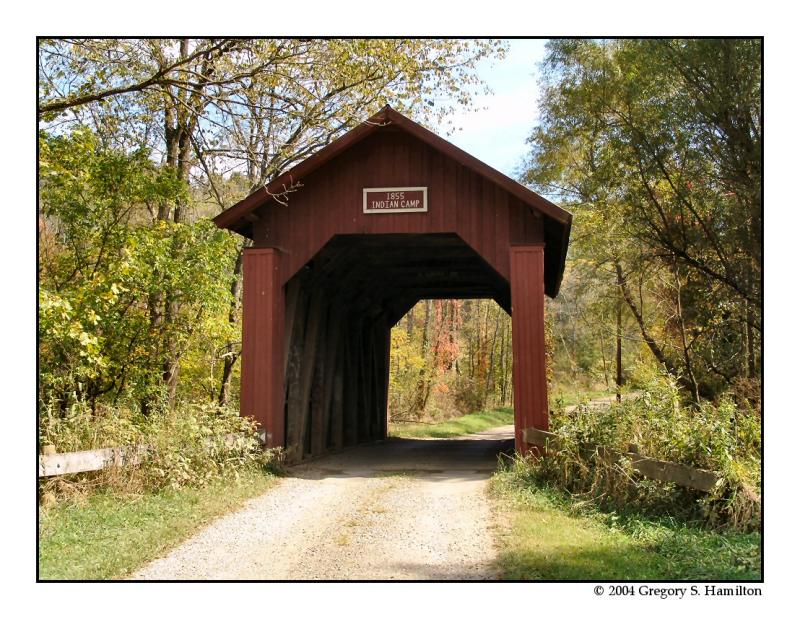
Cambridge
|
35-30-04 |
North-west of Cambridge on Knox Road TR 68 Au nord-ouest de Cambridge sur la TR68, le chemin Knox Nord-westlich von des Dorf Cambridge auf TR68, Knox Weg |
Indian Camp Run Ruisseau du camp Indien Indien Lager Bach |
Indian Camp Bridge Pont couvert du camp Indien Indien Lager |
5.3 miles north-west of OH209 on OH658 and right 0.1 mile on Knox Road TR68 to the bridge 5.3 au nord-ouest de la OH209 sur la OH568 et à droite sur le chemin Knox TR68 .1 mile vers le pont 5,3 Meilen nord-westlich von OH209 auf OH658 und rechts auf 0,1 Meile Knox Road TR68 auf der Brücke |
1 |
36' 11m |
Built in 1855, rehabilitated in 1999 Construit 1855, réhabilité en 1999 Gebaut in 1855, renoviert im Jahr 1999 |
Multiple King post truss Ferme à pointçon multiples Einfaches Hängewerk |

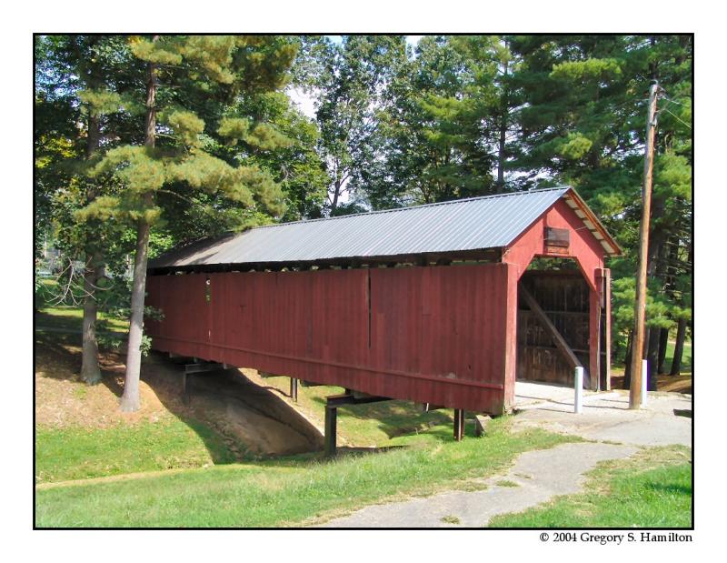
|
35-30-12 |
In the northern section of Cambridge at City Park. Au parc municipal dans la section nord de Cambridge In den nördlichen Teil von Cambridge am Stadt Park |
Ravine Ravin Schlucht |
Armstrong or Clio Bridge, closed to motor traffic Pont couvert Armstrong ou de Clio, fermé au véhicules moteur Armstrong oder Clio Holzbrücke, Fahrzeugverkehr verboten |
About 1 mile north of US22/40 Wheeling Ave. between 6th and 8th Streets on the north side on park access road Environ 1 mile au nord des US22/40, l’avenue Wheeling, entre les 6 et 8e rue au nord du chemin d’accès du parc municipal Ungfahr 1 Meile nördlich von US22/40 Wheeling Ave. zwischen 6. und 8. Straßen auf der Nordseite am Park Zufahrtsstraß |
1 |
76' 23.2m |
Built in 1849 at Clio, moved to Cambridge city park in 1966 Construit en 1849 à Clio, déménagé à Cambridge en 1966 Gebaut in 1849 in des Dorf Clio, umgebaut in Cambridge Stadtpark im Jahr 1966 |
Multiple King post truss Ferme à pointçon multiples Eiinfaches Hängewerk |

Cumberland
| 35-30-A |
West of Cumberland in Spencer Township À l'ouest de Cumberland dans le canton Spencer Südlich von Cumberland in Landkreis Spencer |
Miller Creek Ruisseau Miller Miller Bach |
Mail Pouch Tobacco Bridge, private Pont couvert du tabac Mail Pouch, privé Mail-Pouch Holzbrücke, privat |
1 mile from OH83 on OH340 at the western edge of Cumberland on the south. side of the road. 1 mile de la OH83 sur la OH340 à la limite ouest de Cumberland du côté sud de la route 1 Meile von OH83 auf OH340 am westlichen Rand von Cumberland auf der Südseite der Straße. |
1 | 42' 12.8m |
Built in 1982 Construit en 1982 Gebaut in 1982 |
Stringer Poutres continues Trägbalken |

Foto Mark Comstock from the outstanding DALE TRAVIS web page!!!
- Home
Acceuil
Startseite
主页 - To The Bridges
Vers les ponts
Zum die Brücken
通往棚桥- America Amerique
美洲 Amerika- USA-United States of America
États-Unis d'Amérique
Vereinigte Staaten von Amerika East/Est/Ost美利坚合众国 - Carolinas North 33 & South 40
Caroline du nord et du sud - Connecticut 07
- Delaware 08
- Georgia Georgie 10
- Maine 19
- Maryland 20
- Massachusetts 21
- New-Hampshire 29
- New-Jersey 30
- New-York 32
- Albany 32-01
- Broome 32-04
- Cattaragus 32-05
- Cayuga 32-06
- Delaware 32-13
- Erie 32-15
- Essex 32-16
- Fulton 32-18
- Genesee 32-19
- Herkimer 32-22
- Jefferson 32-23
- Lewis 32-25
- Madison 32-27
- Oneida 32-33
- Ostego 32-39
- Rensselaer 32-42
- Saratoga 32-46
- Schoharie 32-47
- Schuyler 32-48
- Steuben 32-51
- Suffolk 32-52
- Sullivan 32-53
- Tompkins 32-55
- Ulster 32-56
- Warren 32-57
- Washington 32-58
- Pennsylvania Pennsylvanie 38
- Adams 38-01
- Bedford 38-05
- Berks 38-06
- Bradford 38-08
- Bucks 38-09
- Carbon 38-13
- Chester 38-15
- Clearfield 38-17
- Clinton 38-18
- Columbia 38-19
- Cumberland 38-21
- Dauphin 38-22
- Erie 38-25
- Franklin 38-28
- Greene 38-30
- Huntingdon 38-31
- Indiana 38-32
- Jefferson 38-33
- Juniata 38-34
- Lancaster 38-36
- Lawrence 38-37
- Lehigh 38-39
- Lycoming 38-41
- Mercer 38-43
- Montour 38-47
- Northampton 38-48
- Northumberland 38-49
- Perry 38-50
- Philadelphia 38-51
- Schuylkill 38-54
- Snyder 38-55
- Somerset 38-56
- Sullivan 38-57
- Susquehanna 38-58
- Union 38-60
- Washington 38-63
- Westmoreland 38-65
- York 38-67
- Rhode-Island Île-de-Rhode 39
- Vermont 45
- Virginia Virginie 46
- West-Virginia 48
Virginie Occidentale
- Carolinas North 33 & South 40
- USA-Mid-West / Centre Ouest / Mittelwest
中间西 - Illinois 13
- Indiana 14
- Adams 14-01
- Allen 14-02
- Bartholomew 14-03
- Brown 14-07
- Carroll 14-08
- Clark 14-10
- Dearborn 14-15
- Decatur 14-16
- Dekalb 14-17
- Elkhart 14-20
- Fayette 14-21
- Fountain 14-23
- Franklin 14-24
- Gibson 14-26
- Grant 14-27
- Greene 14-28
- Hamilton 14-29
- Howard 14-34
- Jackson 14-36
- Jennings 14-40
- Kociusko 14-43
- Lake 14-45
- Lawrence 14-47
- Marion 14-49
- Montgomery 14-54
- Owen 14-60
- Parke 14-61
- Perry 14-62
- Putnam 14-67
- Ripley 14-69
- Rush 14-70
- Spencer 14-74
- Vermillion 14-83
- Vigo 14-84
- Wabash 14-85
- Iowa 15
- Kentucky 17
- Michigan 22
- Minnesota 23
- Missouri 25
- Ohio 35
- Adams 35-01
- Ashland 35-03
- Ashtabula 35-04
- Athens 35-05
- Auglaize 35-06
- Belmont 35-07
- Brown 35-08
- Buttler 35-09
- Carroll 35-10
- Clermont 35-13
- Clinton 35-14
- Columbiana 35-15
- Coschocton 35-16
- Cuyahoga 35-18
- Delaware 35-21
- Fairfield 35-23
- Franklin 35-25
- Geauga 35-28
- Greene 35-29
- Guernsey 35-30
- Hamilton 35-31
- Harrison 35-34
- Highland 35-36
- Holmes 35-38
- Jackson 35-40
- Jefferson 35-41
- Knox 35-42
- Lake 35-43
- Lawrence 35-44
- Licking 35-45
- Logan 35-46
- Lucas 35-47
- Mahoning 35-50
- Miami 35-55
- Monroe 35-56
- Montgomery 35-57
- Morgan 35-58
- Muskingum 35-60
- Noble 35-61
- Ottawa 35-62
- Perry 35-64
- Pickaway 35-65
- Preble 35-68
- Ross 35-71
- Sandusky 35-72
- Scioto 35-73
- Summit 35-77
- Trumbull 35-78
- Union 35-80
- Vinton 35-82
- Washington 35-84
- Wayne 35-85
- Williams 35-86
- Wyandot 35-88
- Oklahoma 36
- Tennessee 42
- Wisconsin 49
- USA-Deep South & Far West / Sud & Far-ouest /
Süd und Far-West西和南 - Canada Kanada
加拿大 - British-Columbia 52
- New-Brunswick 55
- Ontario 59
- Quebec 61
- Abitibi-est 61-01
- Abitibi-ouest 61-02
- Arthabaska 61-06
- Beauce sud 61-08
- Berthier 61-11
- Bonaventure 61-14
- Brome-Missisquoi 61-18
- Charlevoix 61-23
- Drummond 61-32
- Dubuc 61-33
- Gaspé 61-37
- Gatineau 61-38
- Huntingdon 61-43
- Johnson 61-50
- Kamouraska-Témiskouata 61-53
- Labelle 61-54
- Laviolette 61-64
- Lotbinière 61-66
- Matane 61-74
- Matapédia 61-75
- Mégantic-Compton 61-76
- Montmagny-L'Islet 61-80
- Nicolet-Yamaska 61-84
- Orford 61-86
- Pontiac 61-90
- René-Levesque 61-93
- Richelieu 61-94
- Richmond 61-95
- Rimouski 61-96
- Roberval 61-99
- Rousseau 61-101
- Rouyn-Noranda-Témiscamingue 61-102
- St-François 61-103
- St-Maurice 61-109
- Westmount-St-Louis 61-125
- Colombia Colombie Kolumbien
- Mexico Méxique Mexiko
- Peru Pérou / Ecuador Équateur
- USA-United States of America
- Asia Asie Asien
亚洲- 不丹王国
Bhutan Bhoutan - 人民共和国的中国 China Chine
- 印度尼西亚
Indonesia Indonésie - 日本
Japan Japon - 马来西亚
Malaysia Malaisie - 新加坡
Singapura Singapore Singapour SG-01 - 斯里兰卡
Sri-Lanka SR-01 - 泰国
Thailand Thaïlande - 越南
Viet Nam
- 不丹王国
- Europe Europa
欧洲- Belgique Belgium Belgien
比利时 - Czech Republik Tchèquie
Tschechische Republik捷克语 - Bohème du Sud / Südböhmen
South-Bohemia CZ-01 - Moravie du Sud / Südmähren
South-Moravia CZ-02 - Bohème centrale / Mittelböhmen
Central-Bohemia CZ-03 - Prague / Prag / Praha CZ-04
- Région de Pardubice/ Die Region Pardubice
Pardubice Region CZ-05 - Les terres-hautes de Vysočina / Die Region Vysočina / Vysočina Highland Region
CZ-06 - Bohème de l'ouest/ Westböhmen
Western-Bohemia CZ-07 - Bohème du Nord / Nordböhmen
North-Bohemia CZ-09
- Bohème du Sud / Südböhmen
- Deutschland Germany Allemagne
德国 - Baden-Württemberg /
Bade Wurtemberg D-01 - Bayern / Bavière / Bavaria D-02
- Berlin D-03
- Brandenburg / Brandebourg
D-04 - Hessen / Hesse D-07
- Niedersachsen / Basse Saxe /
Lower Saxony D-09 - Nordrhein-Westfalen D-10 / Rhineland-Westphalia / Rhénanie du nord Westphalie
- Rheinland-Pfalz D-11 /
Rhineland Palatinat /
Rhénanie Palatinat - Sachsen / Saxonia / Saxe D-13
- Sachsen Anhalt / Saxe Anhalt / Saxonia Anhalt D-14
- Thüringen / Thuringe / Thuringia D-16
- Baden-Württemberg /
- Espana Espagne Spain Spanien
西班牙 - France Frankreich
法国 - Great-Britain Grande-Bretagne Großbritannien
大不列颠 - Italia Italy Italie Italien
意大利 - Norway Norvège Norwegen
挪威 - Österreich Austria
Autriche奥地利 - Russia Russie Russland
俄罗斯 - Suisse Schweiz Switzerland
瑞士 - Sweden Suède Schweden
瑞典
- Belgique Belgium Belgien
- America Amerique
- Subscribe
Abonnement
Abonnement
订阅 - Advertise
Annoncez
Werben
广告 - Contact
Contact
Kontakt
联络方式 - Questions?
Questions?
Fragen?
问题 - Special
Spécial
Besondere
特别 - Internet Links
Liens internet
Verbindungen
连接


